
Reykjavik topographic map
Interactive map
Click on the map to display elevation.
About this map
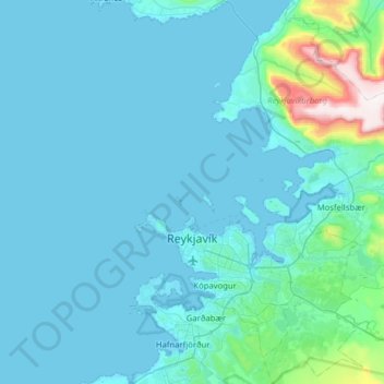
Name: Reykjavik topographic map, elevation, terrain.
Location: Reykjavik, Capital Region, Iceland (64.04040 -21.98383 64.31537 -21.40200)
Average elevation: 67 m
Minimum elevation: -3 m
Maximum elevation: 866 m
Other topographic maps
Click on a map to view its topography, its elevation and its terrain.