
Thank you for supporting this site ❤️
Make a donation
Make a donation
Park County topographic map
Click on the map to display elevation.
Thank you for supporting this site ❤️
Make a donation
Make a donation
About this map
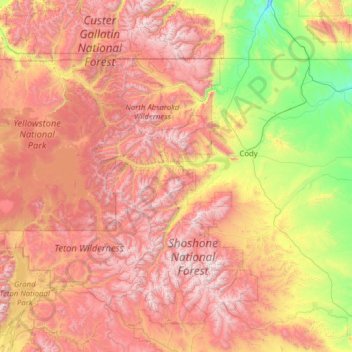
Name: Park County topographic map, elevation, terrain.
Location: Park County, Wyoming, United States (43.80116 -111.05527 45.00583 -108.55056)
Average elevation: 2,257 m
Minimum elevation: 1,124 m
Maximum elevation: 3,870 m
Thank you for supporting this site ❤️
Make a donation
Make a donation
Other topographic maps
Click on a map to view its topography, its elevation and its terrain.
Thank you for supporting this site ❤️
Make a donation
Make a donation
Casper Mountain
United States > Wyoming > Natrona County
Casper Mountain, an anticline, is located at the north end of the Laramie Mountains overlooking Casper, Wyoming along the North Platte River. At a top elevation of 8,130 feet (2,478 m), the geological feature rises approximately 3,000 feet (914 m) above Casper.
Average elevation: 2,315 m