Geolocate

Würzburg topographic map

Interactive map

Click on the map to display elevation.

Würzburg

Würzburg covers an area of 87.6 square kilometres and lies at an altitude of around 177 metres.

Wikipedia (CC-BY-SA 3.0)

About this map

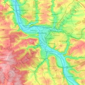
Name: Würzburg topographic map, elevation, terrain.

Location: Würzburg, Bavaria, Germany (49.71068 9.87163 49.84546 10.01443)

Average elevation: 270 m

Minimum elevation: 166 m

Maximum elevation: 385 m

Other topographic maps

Click on a map to view its topography, its elevation and its terrain.

Zugspitze

Germany > Bavaria > Landkreis Garmisch-Partenkirchen > Grainau

The mountain rises eleven kilometres southwest of Garmisch-Partenkirchen and just under six kilometres east of Ehrwald. The border between Germany and Austria runs over the west summit; thus the Zugspitze massif belongs to the German state of Bavaria and the Austrian state of Tyrol. The municipalities…

Average elevation: 2,300 m

Wildbad Kreuth

Germany > Bavaria > Landkreis Miesbach > Kreuth

Average elevation: 1,021 m

Seeon

Germany > Bavaria > Landkreis Traunstein > Seeon-Seebruck

Average elevation: 544 m

Allgäu

Germany > Bavaria

Average elevation: 1,087 m

Wella

Germany > Bavaria > Landkreis Mühldorf am Inn > Berg

Average elevation: 566 m

Hainbronn

Germany > Bavaria > Landkreis Bayreuth > Pegnitz

Average elevation: 467 m

Katterbach

Germany > Bavaria > Ansbach

Average elevation: 452 m

Wind

Germany > Bavaria > Landkreis Bamberg

Average elevation: 284 m

Würgau

Germany > Bavaria > Landkreis Bamberg > Scheßlitz

Average elevation: 472 m

Hunas

Germany > Bavaria > Nürnberger Land > Hartmannshof > Hunas

Average elevation: 472 m

Drainage

Germany > Bavaria > Schwabmünchen

Average elevation: 584 m

Langenhettenbach

Germany > Bavaria > Langenhettenbach

Average elevation: 452 m

Manthal

Germany > Bavaria > Landkreis Starnberg > Harkirchen > Manthal

Average elevation: 623 m

Enthal

Germany > Bavaria > Bergen > Enthal

Average elevation: 592 m

Rederzhausen

Germany > Bavaria > Friedberg > Rederzhausen

Average elevation: 501 m

Hard

Germany > Bavaria > Landkreis Eichstätt > Hard

Average elevation: 472 m