
Thank you for supporting this site ❤️
Make a donation
Make a donation
Flöthe topographic map
Click on the map to display elevation.
Thank you for supporting this site ❤️
Make a donation
Make a donation
Flöthe
Der höchste Punkt der Gemeinde liegt am Südhang des Hungerbergs im Oderwald und hat eine Höhe von 188 m ü. NHN.
Thank you for supporting this site ❤️
Make a donation
Make a donation
About this map
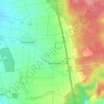
Name: Flöthe topographic map, elevation, terrain.
Average elevation: 140 m
Minimum elevation: 98 m
Maximum elevation: 207 m
Thank you for supporting this site ❤️
Make a donation
Make a donation