
Frederiksberg Municipality topographic map
Interactive map
Click on the map to display elevation.
About this map
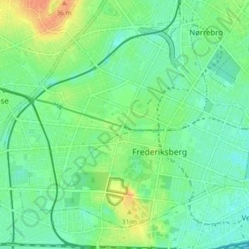
Name: Frederiksberg Municipality topographic map, elevation, terrain.
Location: Frederiksberg Municipality, Capital Region of Denmark, Denmark (55.66650 12.49132 55.69768 12.55734)
Average elevation: 15 m
Minimum elevation: 2 m
Maximum elevation: 39 m
Other topographic maps
Click on a map to view its topography, its elevation and its terrain.
Birkerød
Denmark > Capital Region of Denmark
Birkerød, Rudersdal Municipality, Capital Region of Denmark, 3460, Denmark
Average elevation: 40 m
Frederiksberg
Denmark > Capital Region of Denmark
Frederiksberg, Frederiksberg Municipality, Capital Region of Denmark, 1861, Denmark
Average elevation: 11 m
Hvidovre Municipality
Denmark > Capital Region of Denmark
Hvidovre Municipality, Capital Region of Denmark, 2650, Denmark
Average elevation: 5 m
Hillerød
Denmark > Capital Region of Denmark > Hillerød
Hillerød, Hillerød Municipality, Capital Region of Denmark, 3400, Denmark
Average elevation: 36 m