
Juárez topographic map
Interactive map
Click on the map to display elevation.
About this map
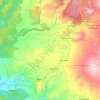
Name: Juárez topographic map, elevation, terrain.
Location: Juárez, Michoacán, Mexico (19.23656 -100.54671 19.35035 -100.37776)
Average elevation: 1,309 m
Minimum elevation: 630 m
Maximum elevation: 2,227 m
Other topographic maps
Click on a map to view its topography, its elevation and its terrain.
Jacona de Plancarte
Jacona de Plancarte, Jacona, Michoacán, 59893, Mexico
Average elevation: 1,631 m