
Thank you for supporting this site ❤️
Make a donation
Make a donation
Leidschendam topographic map
Click on the map to display elevation.
Thank you for supporting this site ❤️
Make a donation
Make a donation
About this map
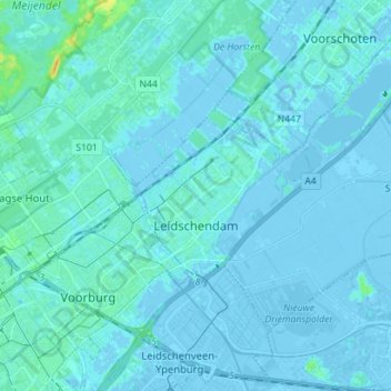
Name: Leidschendam topographic map, elevation, terrain.
Location: Leidschendam, Leidschendam-Voorburg, South Holland, Netherlands (52.05625 4.35228 52.12898 4.49302)
Average elevation: 1 m
Minimum elevation: -8 m
Maximum elevation: 22 m
Thank you for supporting this site ❤️
Make a donation
Make a donation
Other topographic maps
Click on a map to view its topography, its elevation and its terrain.
Thank you for supporting this site ❤️
Make a donation
Make a donation
Thank you for supporting this site ❤️
Make a donation
Make a donation
Thank you for supporting this site ❤️
Make a donation
Make a donation