
Chandler's Ford topographic map
Interactive map
Click on the map to display elevation.
About this map
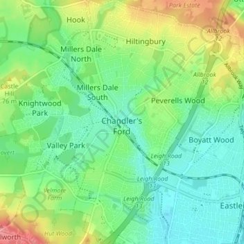
Name: Chandler's Ford topographic map, elevation, terrain.
Location: Chandler's Ford, Eastleigh, Hampshire, England, United Kingdom (50.96252 -1.39965 51.00437 -1.35715)
Average elevation: 39 m
Minimum elevation: 10 m
Maximum elevation: 96 m
Other topographic maps
Click on a map to view its topography, its elevation and its terrain.
Cow Down
United Kingdom > England > Hampshire > Test Valley
Cow Down, Test Valley, Hampshire, England, SP11 9HE, United Kingdom
Average elevation: 193 m
Fareham
United Kingdom > England > Hampshire
Fareham, Hampshire, England, United Kingdom
Average elevation: 21 m
Basingstoke
United Kingdom > England > Hampshire > Basingstoke and Deane
Basingstoke, Basingstoke and Deane, Hampshire, England, United Kingdom
Average elevation: 110 m
North Street
United Kingdom > England > Hampshire > East Hampshire > Ropley > North Street
North Street, Ropley, East Hampshire, Hampshire, England, SO24 0DF, United Kingdom
Average elevation: 143 m