
Marquette County topographic map
Interactive map
Click on the map to display elevation.
About this map
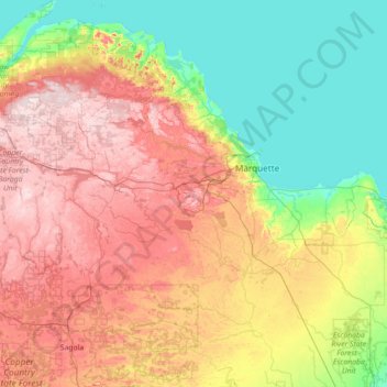
Name: Marquette County topographic map, elevation, terrain.
Location: Marquette County, Michigan, United States (45.98504 -88.11755 46.96663 -87.11604)
Average elevation: 332 m
Minimum elevation: 176 m
Maximum elevation: 594 m
Other topographic maps
Click on a map to view its topography, its elevation and its terrain.
Negaunee
United States > Michigan > Marquette County
Negaunee, Marquette County, Michigan, 49866, United States
Average elevation: 441 m