
Thank you for supporting this site ❤️
Make a donation
Make a donation
Oingt topographic map
Click on the map to display elevation.
Thank you for supporting this site ❤️
Make a donation
Make a donation
Oingt
The municipal area stretches along a north–south axis over several hills. The historic village is located at the top of one of these hills at an elevation of about 520 metres. The highest point in the municipality is found on a hill to the north-east of the village, at 652 metres. Nizy Creek, whose source is to the east of the village, falls towards the south along a small valley, reaching 358 metres at the town boundary.
Thank you for supporting this site ❤️
Make a donation
Make a donation
About this map
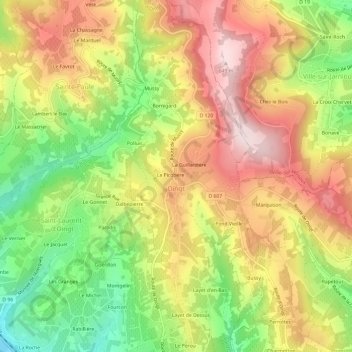
Name: Oingt topographic map, elevation, terrain.
Average elevation: 462 m
Minimum elevation: 258 m
Maximum elevation: 651 m
Thank you for supporting this site ❤️
Make a donation
Make a donation