
Thank you for supporting this site ❤️
Make a donation
Make a donation
Badung topographic map
Click on the map to display elevation.
Thank you for supporting this site ❤️
Make a donation
Make a donation
About this map
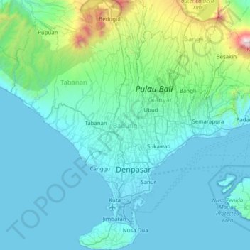
Name: Badung topographic map, elevation, terrain.
Location: Badung, Bali, Lesser Sunda Islands, Indonesia (-8.85043 115.08383 -8.23944 115.25139)
Average elevation: 311 m
Minimum elevation: -1 m
Maximum elevation: 3,004 m
Thank you for supporting this site ❤️
Make a donation
Make a donation
Other topographic maps
Click on a map to view its topography, its elevation and its terrain.
Denpasar
Indonesia > Bali > Dangin Puri
Denpasar is located at an elevation of 4 m (13 ft) above sea level. While the total area of 125.98 km2 or 2.18% of the total area of Bali Province. From the use of land, 2,768 hectares of land are paddy, 10,001 hectares are dry land, while the remaining land area is 9 hectares.
Average elevation: 48 m
Thank you for supporting this site ❤️
Make a donation
Make a donation