
Thank you for supporting this site ❤️
Make a donation
Make a donation
Kebayoran Baru topographic map
Click on the map to display elevation.
Thank you for supporting this site ❤️
Make a donation
Make a donation
About this map
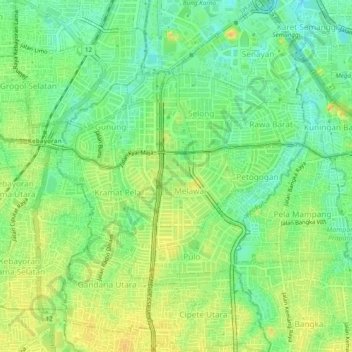
Name: Kebayoran Baru topographic map, elevation, terrain.
Average elevation: 22 m
Minimum elevation: 7 m
Maximum elevation: 37 m
Thank you for supporting this site ❤️
Make a donation
Make a donation
Other topographic maps
Click on a map to view its topography, its elevation and its terrain.
Pulau Bidadari
Indonesia > Special Capital Region of Jakarta > Pulau Untung Jawa
Average elevation: 0 m