
Make a donation
Denpasar topographic map
Click on the map to display elevation.
Make a donation
Denpasar
Denpasar is located at an elevation of 4 m (13 ft) above sea level. While the total area of 125.98 km2 or 2.18% of the total area of Bali Province. From the use of land, 2,768 hectares of land are paddy, 10,001 hectares are dry land, while the remaining land area is 9 hectares.
Make a donation
About this map
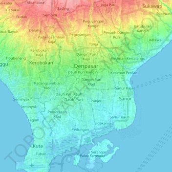
Name: Denpasar topographic map, elevation, terrain.
Location: Denpasar, Bali, Lesser Sunda Islands, Indonesia (-9.03749 115.17319 -8.59084 115.45215)
Average elevation: 7 m
Minimum elevation: -1 m
Maximum elevation: 207 m
Make a donation
Other topographic maps
Click on a map to view its topography, its elevation and its terrain.
Denpasar
Indonesia > Bali > Dangin Puri
Denpasar is located at an elevation of 4 m (13 ft) above sea level. While the total area of 125.98 km2 or 2.18% of the total area of Bali Province. From the use of land, 2,768 hectares of land are paddy, 10,001 hectares are dry land, while the remaining land area is 9 hectares.
Average elevation: 48 m
Make a donation