
Shaker Heights topographic map
Interactive map
Click on the map to display elevation.
Shaker Heights
Shaker Heights was established in 1909, and incorporated as a village in 1912. Shaker Heights is home to the oldest house in Cuyahoga County, built in 1817 by Moses Warren. The name "Shaker Heights" has origins in two local sources. The community was laid out on land formerly owned by the North Union Community of the United Society of Believers in Christ's Second Appearing, more commonly known as Shakers. "Heights" refers to the plateau east of Cleveland that rises sharply in elevation from 582 feet above sea level at the base of the Cedar Glen Parkway rising to 950 feet above sea level in nearby Cleveland Heights; Shaker Heights' elevation is 1050 feet above sea level.
About this map
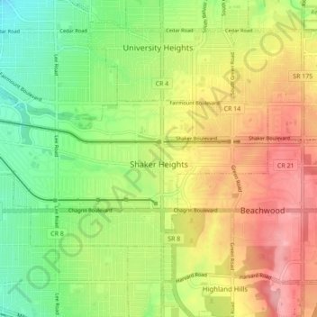
Name: Shaker Heights topographic map, elevation, terrain.
Location: Shaker Heights, Cuyahoga County, Ohio, 44120, United States (41.45706 -81.59373 41.49295 -81.50712)
Average elevation: 323 m
Minimum elevation: 267 m
Maximum elevation: 386 m
Other topographic maps
Click on a map to view its topography, its elevation and its terrain.
Cleveland
United States > Ohio > Cuyahoga County > Cleveland
The land rises quickly from the lake shore elevation of 569 feet. Public Square, less than one mile (1.6 km) inland, sits at an elevation of 650 feet (198 m), and Hopkins Airport, 5 miles (8 km) inland from the lake, is at an elevation of 791 feet (241 m).
Average elevation: 219 m