
Thank you for supporting this site ❤️
Make a donation
Make a donation
Bannock County topographic map
Click on the map to display elevation.
Thank you for supporting this site ❤️
Make a donation
Make a donation
About this map
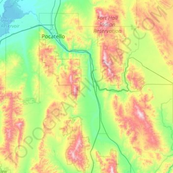
Name: Bannock County topographic map, elevation, terrain.
Location: Bannock County, Idaho, United States (42.25628 -112.75234 43.02259 -111.87548)
Average elevation: 1,746 m
Minimum elevation: 1,322 m
Maximum elevation: 2,807 m
Thank you for supporting this site ❤️
Make a donation
Make a donation
Other topographic maps
Click on a map to view its topography, its elevation and its terrain.
Thank you for supporting this site ❤️
Make a donation
Make a donation
Boise
United States > Idaho > Ada County > Boise
Boise (/ˈbɔɪsi/ (listen) BOY-see) is the capital and most populous city of the U.S. state of Idaho and is the county seat of Ada County. On the Boise River in southwestern Idaho, it is 41 miles (66 km) east of the Oregon border and 110 miles (177 km) north of the Nevada border. The downtown area's elevation…
Average elevation: 1,040 m