
Los Cabos Municipality topographic map
Interactive map
Click on the map to display elevation.
About this map
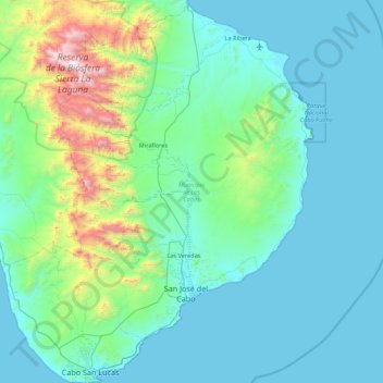
Name: Los Cabos Municipality topographic map, elevation, terrain.
Location: Los Cabos Municipality, Baja California Sur, Mexico (22.87163 -110.12066 23.67148 -109.41317)
Average elevation: 278 m
Minimum elevation: 0 m
Maximum elevation: 2,054 m
The municipality has an average altitude of forty meters above sea level. There are three main terrain types, mountain terrain, semi flat areas and flat areas. The mountains consist of the Sierra de la Laguna and the Sierra de San Lázaro, both formed of volcanic rock, covering about fifteen percent of the total territory with peaks between 400 and 1000 meters. The semi flat areas are located between the coast and the mountain ranges, mostly of sedimentary rock and account for sixty percent of the territory. The flat areas are along the coast, beaches and alluvial plains, which account for twenty five percent of the territory.
Other topographic maps
Click on a map to view its topography, its elevation and its terrain.
Municipio de Loreto
Municipio de Loreto, Baja California Sur, Mexico
Average elevation: 171 m
Municipio de Comondú
Municipio de Comondú, Baja California Sur, Mexico
Average elevation: 67 m
Municipio de Mulegé
Municipio de Mulegé, Baja California Sur, Mexico
Average elevation: 109 m
Municipio de La Paz
Municipio de La Paz, Baja California Sur, Mexico
Average elevation: 106 m
San José del Cabo
Mexico > Baja California Sur > San José del Cabo
San José del Cabo, Los Cabos, Baja California Sur, 23400, Mexico
Average elevation: 160 m