
Thank you for supporting this site ❤️
Make a donation
Make a donation
Montserrado County topographic map
Click on the map to display elevation.
Thank you for supporting this site ❤️
Make a donation
Make a donation
About this map
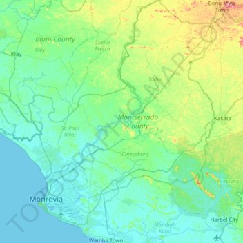
Name: Montserrado County topographic map, elevation, terrain.
Location: Montserrado County, Liberia (6.21811 -10.95909 6.83086 -10.36794)
Average elevation: 52 m
Minimum elevation: -2 m
Maximum elevation: 323 m
Thank you for supporting this site ❤️
Make a donation
Make a donation
Other topographic maps
Click on a map to view its topography, its elevation and its terrain.