
Mont-Tremblant topographic map
Interactive map
Click on the map to display elevation.
Mont-Tremblant
The city is dominated by Mont Tremblant with an altitude of 968m which is one of the highest peaks in southern Quebec.
About this map
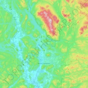
Name: Mont-Tremblant topographic map, elevation, terrain.
Location: Mont-Tremblant, Les Laurentides, Laurentides, Quebec, Canada (46.03810 -74.67667 46.31503 -74.50408)
Average elevation: 358 m
Minimum elevation: 186 m
Maximum elevation: 923 m
Other topographic maps
Click on a map to view its topography, its elevation and its terrain.
Mont Sainte-Agathe
Canada > Quebec > Les Laurentides > Sainte-Agathe-des-Monts
Average elevation: 448 m
Saint-Faustin
Canada > Quebec > Les Laurentides > Saint-Faustin–Lac-Carré > Saint-Faustin-Lac-Carré
Average elevation: 414 m