Geolocate

Cebu topographic map

Click on the map to display elevation.

Cebu

Coal was first discovered in Cebu about 1837. There were 15 localities over the whole island, on both coasts; some desultory mining had been carried out Naga near Mount Uling, but most serious operations were at Licos and Camansi west of Compostela and Danao. Active work ceased about 1895 with the insurrections, and no production was worked on for more than ten years. A topographic and geologic survey of Compostela, Danao, and Carmen took place in 1906. The Compostela-Danao coalfield contained about six million workable tons. The tramroads, one from Danao to Camansi, one from Compostela to Mount Licos, were undertaken in 1895, together with a wagon road built in 1877, from Cotcot to Dapdap.

Wikipedia (CC-BY-SA 3.0)

About this map

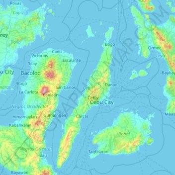
Name: Cebu topographic map, elevation, terrain.

Location: Cebu, Central Visayas, Philippines (9.32234 123.23527 11.62387 124.66718)

Average elevation: 91 m

Minimum elevation: -2 m

Maximum elevation: 2,362 m

Other topographic maps

Click on a map to view its topography, its elevation and its terrain.

Quezon City

Philippines

Founded as a pueblo by Saint Pedro Bautista in 1590, San Francisco del Monte may be considered Quezon City's oldest district. The original land area of the old town of San Francisco del Monte was approximately2.5 square kilometres (1.0 sq mi) and covered parts of what is currently known as Project 7 and 8 and…

Average elevation: 57 m

Gupa

Philippines > Aurora

Average elevation: 62 m

Legazpi

Philippines > Albay

Legazpi's topography is generally plain on the northeastern areas, with slopes ranging from five to fifteen degrees. The southern areas have mostly rolling to hilly terrain. In the city's coastal areas, the terrain varies from plain (north) to hilly (south). Legazpi is criss-crossed by several rivers including…

Average elevation: 150 m

Mount Banahaw

Philippines > Quezon > Tayabas

The andesitic Banahaw volcanic complex is composed of several stratovolcanoes with Mount Banahaw, the largest with a maximum elevation of 2,170 metres (7,119 ft) above mean sea level. The summit is topped by a 1.5 by 3.5 kilometres (0.93 mi × 2.17 mi) and 210 metres (690 ft) deep crater that is breached on…

Average elevation: 1,730 m

Cebu City

Philippines > Cebu > Cebu City

Average elevation: 140 m

Indang

Philippines > Cavite > Indang

The topography of Indang is characterised by gently sloping or rolling terrain. Almost 40.36% of its total land area is within the slope grade of 3-8%, while 2,135 hectares is within the slope range of 8-15% which is characterised by undulating or sloping terrain.

Average elevation: 298 m

Dagupan

Philippines > Pangasinan

Average elevation: 12 m

Butuan

Philippines

Average elevation: 115 m

Antipolo

Philippines > Rizal

Its higher elevation than that of Metro Manila affords it a scenic view of the metropolis, especially at night. Its locally grown mangoes and cashews are popular among tourists, as well as suman – a local delicacy made out of glutinous rice. The Hinulugang Taktak National Park, which was once a popular…

Average elevation: 125 m

Taguig

Philippines

Average elevation: 39 m

Valencia

Philippines > Negros Oriental > Valencia

Valencia occupies an area of 14,749 hectares (36,450 acres), 35% of which are classified as plains. The town is 65% mountainous, with elevation averaging from 200 to 500 metres (660 to 1,640 ft) above sea level, with the top of Mount Talinis at an elevation of 1,903 metres (6,243 ft) along the municipal…

Average elevation: 250 m

Santa Rosa

Philippines > Laguna > Santa Rosa

Average elevation: 65 m

Cavinti

Philippines > Laguna > Cavinti

Average elevation: 250 m

Bacoor

Philippines > Cavite

Average elevation: 18 m

Tarlac

Philippines

Average elevation: 109 m

Molino 4

Philippines > Cavite > Bacoor > Molino 4

Average elevation: 60 m

Iriga

Philippines

Average elevation: 115 m

Liloan

Philippines > Cebu

Average elevation: 17 m

Balaytigue

Philippines > Batangas > Nasugbu

Average elevation: 23 m

Picnic Grove

Philippines > Cavite > Tagaytay

Average elevation: 474 m

Mindoro

Philippines > La Union > Bangar

Average elevation: 3 m

Talim Island

Philippines > Rizal > Kinaboogan

Average elevation: 13 m

Orani

Philippines > Bataan

Average elevation: 11 m

Meycauayan

Philippines > Bulacan

Average elevation: 27 m

Calauag

Philippines > Quezon

Average elevation: 28 m

Tagaytay

Philippines > Cavite

The southern and eastern portions of Tagaytay are covered by hills and mountains which is generally forests, pine trees and open grasslands. The city lies along Tagaytay Ridge, a ridge stretching about 32 kilometres (20 mi) from Mount Batulao in the west to Mount Sungay in the east with elevations averaging…

Average elevation: 229 m

Bacolod

Philippines

Bacólod (English: Bacolod), is derived from bakólod (Old Spelling: bacólod), the Old Hiligaynon (Old Ilonggo) (Old Spelling: Ylongo and Ilongo) word for a "hill, turtle, mound, rise, hillock, down, any small eminence or elevation", since the resettlement was founded on a stony, hilly area, now the barangay…

Average elevation: 49 m

Libod

Philippines > Albay

Average elevation: 131 m

Davao Gulf

Philippines

Average elevation: 0 m

Labangan

Philippines > Zamboanga del Sur

Average elevation: 13 m

Davao City

Philippines

Average elevation: 65 m

Pasig

Philippines

Average elevation: 46 m

Batanes

Philippines

Average elevation: 26 m

Baculin

Philippines > Davao Oriental > Baganga

Average elevation: 10 m

Las Piñas

Philippines

Average elevation: 14 m

Rizal

Philippines

Average elevation: 95 m

Palina

Philippines > Benguet

Average elevation: 1,462 m

Tayud

Philippines > Cebu

Average elevation: 9 m

Silang

Philippines > Cavite > Silang

Average elevation: 305 m

Maydolong

Philippines > Eastern Samar

Average elevation: 14 m

Itogon

Philippines > Benguet

Average elevation: 1,001 m

Ligao

Philippines > Albay

Average elevation: 191 m

Baras

Philippines > Rizal

Average elevation: 46 m

Trece Martires

Philippines > Cavite

The city of Trece Martires is characterised with ground elevation ranging from 30m to nearly 400m. Its ground slope ranges from 0.5 to 2%.

Average elevation: 150 m

Lucban

Philippines

Average elevation: 504 m

Iligan

Philippines

Average elevation: 229 m

Dauin

Philippines > Negros Oriental

Average elevation: 56 m

Danao

Philippines > Cebu

Average elevation: 117 m

Camalig

Philippines > Albay

Average elevation: 191 m

Cabanatuan

Philippines > Nueva Ecija

Average elevation: 47 m

Cabadbaran

Philippines > Agusan del Norte

It is 29 kilometres (18 mi) from Butuan. It is generally flat with rolling hills and swamplands in its western part. The highest of all mountains in the Caraga region, Mount Hilong-Hilong (with an altitude of 2,012 metres (6,601 ft) above sea level), rises in this city.

Average elevation: 179 m

Lapu-Lapu

Philippines

Average elevation: 93 m

Baguio

Philippines

In 1903, Filipinos, Japanese and Chinese workers were hired to build Kennon Road, the first road directly connecting Baguio with the lowlands of La Union and Pangasinan. Before this, the only road to Benguet was Naguilian Road, and it was largely a horse trail at higher elevations. Camp John Hay was…

Average elevation: 881 m

Marikina

Philippines

Average elevation: 80 m

Nueva Era

Philippines > Ilocos Norte

Average elevation: 200 m

Patag Island

Philippines

Average elevation: 0 m

Kota Island

Philippines

Average elevation: 0 m

Lankiam Cay

Philippines

Average elevation: 0 m

Lawak Island

Philippines

Average elevation: 0 m

Kiangan

Philippines > Ifugao

Average elevation: 828 m

Surigao del Sur

Philippines

Average elevation: 274 m

Candaba

Philippines

Average elevation: 6 m

Kinatihan II

Philippines

Average elevation: 22 m

Ibabang Bukal

Philippines

Average elevation: 254 m

Cabatang

Philippines

Average elevation: 335 m

Alno

Philippines > Benguet

Average elevation: 1,005 m

Pinget

Philippines

Average elevation: 1,430 m

Caloocan

Philippines

Average elevation: 81 m

Aurora Hill North Central

Philippines

Average elevation: 1,479 m

Baracatan

Philippines

Average elevation: 357 m

Besigan

Philippines

Average elevation: 584 m

Talomo River

Philippines

Average elevation: 201 m

Asin

Philippines

Average elevation: 1,321 m

Catambungan

Philippines

Average elevation: 5 m

Tablas Strait

Philippines

Average elevation: 0 m

Buenavista

Philippines

Average elevation: 112 m

Poliwes

Philippines

Average elevation: 1,397 m

Teodora Alonzo

Philippines

Average elevation: 1,459 m

Manggahan

Philippines

Average elevation: 7 m

Bakakeng Norte

Philippines

Average elevation: 1,379 m

New Carmen

Philippines

Average elevation: 98 m

Malitbog

Philippines > Oriental Mindoro

Average elevation: 18 m

Crossing Bayabas

Philippines

Average elevation: 22 m

Marinduque

Philippines

Average elevation: 54 m

Bakakeng Central

Philippines

Average elevation: 1,412 m

Parañaque

Philippines

Average elevation: 14 m

Pacdal

Philippines

Average elevation: 1,448 m

Macasandig

Philippines

Average elevation: 42 m

Nueva Ecija

Philippines

Average elevation: 112 m

Nueva Vizcaya

Philippines

Average elevation: 107 m

Antique

Philippines

Average elevation: 46 m

Bohol

Philippines

Average elevation: 116 m

Cebu

Philippines

Average elevation: 89 m

Zone IV

Philippines

Average elevation: 4 m

Albay

Philippines

Average elevation: 48 m

Sorsogon

Philippines

Average elevation: 40 m