
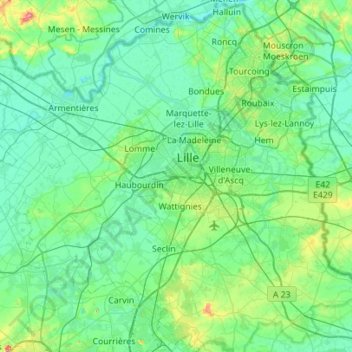
Lille topographic map
Interactive map
Click on the map to display elevation.
About this map
Name: Lille topographic map, elevation, terrain.
Location: Lille, Nord, Hauts-de-France, Metropolitan France, France (50.44163 2.78913 50.79459 3.32911)
Average elevation: 32 m
Minimum elevation: 9 m
Maximum elevation: 162 m
Other topographic maps
Click on a map to view its topography, its elevation and its terrain.
Quéant
France > Hauts-de-France > Pas-de-Calais
Quéant, Arras, Pas-de-Calais, Hauts-de-France, Metropolitan France, 62860, France
Average elevation: 85 m
Noreuil
France > Hauts-de-France > Pas-de-Calais
Noreuil, Arras, Pas-de-Calais, Hauts-de-France, Metropolitan France, 62128, France
Average elevation: 97 m
Rue de Sivry
France > Hauts-de-France > Nord > Beaurieux
Rue de Sivry, Beaurieux, Avesnes-sur-Helpe, Nord, Hauts-de-France, Metropolitan France, 59740, France
Average elevation: 219 m
Amiens
France > Hauts-de-France > Somme
Amiens, Somme, Hauts-de-France, Metropolitan France, France
Average elevation: 55 m
Tourcoing
France > Hauts-de-France > Nord
Tourcoing, Lille, Nord, Hauts-de-France, Metropolitan France, 59200, France
Average elevation: 39 m
Villeneuve-d'Ascq
France > Hauts-de-France > Nord
Villeneuve-d'Ascq, Lille, Nord, Hauts-de-France, Metropolitan France, France
Average elevation: 33 m
Beauvais
France > Hauts-de-France > Oise
Beauvais, Oise, Hauts-de-France, Metropolitan France, 60000, France
Average elevation: 99 m
Sachin
France > Hauts-de-France > Pas-de-Calais
Sachin, Arras, Pas-de-Calais, Hauts-de-France, Metropolitan France, 62550, France
Average elevation: 148 m
Borre
France > Hauts-de-France > Nord
Borre, Dunkirk, Nord, Hauts-de-France, Metropolitan France, 59190, France
Average elevation: 25 m
Clermont
France > Hauts-de-France > Oise
Clermont, Oise, Hauts-de-France, Metropolitan France, 60600, France
Average elevation: 77 m
Wambrechies
France > Hauts-de-France > Nord > Wambrechies
Wambrechies, Lille, Nord, Hauts-de-France, Metropolitan France, 59118, France
Average elevation: 22 m
Dunkirk
France > Hauts-de-France > Nord > Dunkirk
Dunkirk, Nord, Hauts-de-France, Metropolitan France, 59140, France
Average elevation: 3 m
Calais
France > Hauts-de-France > Pas-de-Calais > Calais
Calais, Pas-de-Calais, Hauts-de-France, Metropolitan France, 62100, France
Average elevation: 19 m
Warlencourt-Eaucourt
France > Hauts-de-France > Pas-de-Calais > Warlencourt-Eaucourt
Warlencourt-Eaucourt, Arras, Pas-de-Calais, Hauts-de-France, Metropolitan France, 62450, France
Average elevation: 113 m
Lille
France > Hauts-de-France > Nord > Lille
Lille, Nord, Hauts-de-France, Metropolitan France, 59046, France
Average elevation: 32 m
Amiens
France > Hauts-de-France > Somme > Amiens
Amiens, Somme, Hauts-de-France, Metropolitan France, 80000, France
Average elevation: 86 m
Saleux
France > Hauts-de-France > Somme > Saleux
Saleux, Amiens, Somme, Hauts-de-France, Metropolitan France, 80480, France
Average elevation: 67 m
La Madeleine
France > Hauts-de-France > Nord > La Madeleine
La Madeleine, Lille, Nord, Hauts-de-France, Metropolitan France, 59110, France
Average elevation: 30 m
Lille
France > Hauts-de-France > Nord
Lille, Nord, Hauts-de-France, Metropolitan France, France
Average elevation: 32 m
Arras
France > Hauts-de-France > Arras
Arras, Pas-de-Calais, Hauts-de-France, Metropolitan France, 62000, France
Average elevation: 78 m
Le Quesnel
France > Hauts-de-France > Le Quesnel
Le Quesnel, Montdidier, Somme, Hauts-de-France, Metropolitan France, 80118, France
Average elevation: 94 m
Bailleul-aux-Cornailles
France > Hauts-de-France > Bailleul-aux-Cornailles
Bailleul-aux-Cornailles, Arras, Pas-de-Calais, Hauts-de-France, Metropolitan France, 62127, France
Average elevation: 140 m
Oise
Oise, Hauts-de-France, Metropolitan France, France
Average elevation: 108 m
Gorges
France > Hauts-de-France > Gorges
Gorges, Amiens, Somme, Hauts-de-France, Metropolitan France, 80370, France
Average elevation: 136 m
Zuytpeene
France > Hauts-de-France > Zuytpeene
Zuytpeene, Dunkirk, Nord, Hauts-de-France, Metropolitan France, 59670, France
Average elevation: 37 m
Calais
France > Hauts-de-France > Pas-de-Calais
Calais, Pas-de-Calais, Hauts-de-France, Metropolitan France, 62100, France
Average elevation: 3 m
Bouvines
France > Hauts-de-France > Bouvines
Bouvines, Lille, Nord, Hauts-de-France, Metropolitan France, 59830, France
Average elevation: 35 m
Halluin
France > Hauts-de-France > Halluin
Halluin, Lille, Nord, Hauts-de-France, Metropolitan France, 59250, France
Average elevation: 24 m
Hulluch
France > Hauts-de-France > Hulluch
Hulluch, Lens, Pas-de-Calais, Hauts-de-France, Metropolitan France, 62410, France
Average elevation: 35 m
Bellicourt
France > Hauts-de-France > Bellicourt
Bellicourt, Saint-Quentin, Aisne, Hauts-de-France, Metropolitan France, 02420, France
Average elevation: 128 m
Carnin
France > Hauts-de-France > Carnin
Carnin, Lille, Nord, Hauts-de-France, Metropolitan France, 59112, France
Average elevation: 29 m
Ligny-Thilloy
France > Hauts-de-France > Ligny-Thilloy
Ligny-Thilloy, Arras, Pas-de-Calais, Hauts-de-France, Metropolitan France, 62450, France
Average elevation: 119 m
Deûlémont
France > Hauts-de-France > Deûlémont
Deûlémont, Lille, Nord, Hauts-de-France, Metropolitan France, 59890, France
Average elevation: 18 m
Montépilloy
France > Hauts-de-France > Montépilloy
Montépilloy, Senlis, Oise, Hauts-de-France, Metropolitan France, 60810, France
Average elevation: 98 m
Denain
France > Hauts-de-France > Denain
Denain, Arrondissement de Valenciennes, Nord, Hauts-de-France, Metropolitan France, 59220, France
Average elevation: 38 m
Fayet
France > Hauts-de-France > Fayet
Fayet, Saint-Quentin, Aisne, Hauts-de-France, Metropolitan France, 02100, France
Average elevation: 110 m
terrain de basket
France > Hauts-de-France > Tergnier
terrain de basket, Résidence Lionel Lefèvre, Tergnier, Laon, Aisne, Hauts-de-France, Metropolitan France, 02700, France
Average elevation: 53 m
Marcq-en-Barœul
France > Hauts-de-France > Nord
Marcq-en-Barœul, Lille, Nord, Hauts-de-France, Metropolitan France, 59700, France
Average elevation: 30 m
Lens
France > Hauts-de-France > Pas-de-Calais > Lens
Lens, Pas-de-Calais, Hauts-de-France, Metropolitan France, 62300, France
Average elevation: 44 m
Dunkirk
France > Hauts-de-France > Nord
Dunkirk, Nord, Hauts-de-France, Metropolitan France, France
Average elevation: 2 m
Pas-de-Calais
Pas-de-Calais, Hauts-de-France, Metropolitan France, France
Average elevation: 61 m
Sanghen
France > Hauts-de-France > Pas-de-Calais
Sanghen, Calais, Pas-de-Calais, Hauts-de-France, Metropolitan France, 62850, France
Average elevation: 117 m
Somme
Somme, Hauts-de-France, Metropolitan France, France
Average elevation: 98 m
Aisne
Aisne, Hauts-de-France, Metropolitan France, France
Average elevation: 133 m
Nord
Nord, Hauts-de-France, Metropolitan France, France
Average elevation: 67 m