
Manjeri topographic map
Interactive map
Click on the map to display elevation.
About this map
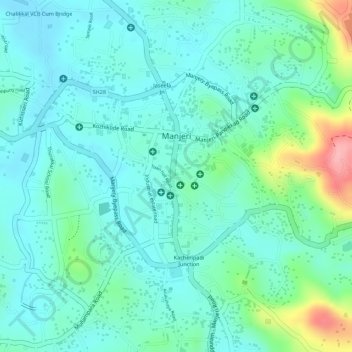
Name: Manjeri topographic map, elevation, terrain.
Location: Manjeri, Ernad, Malappuram District, Kerala, 676121, India (11.10677 76.11085 11.12734 76.13068)
Average elevation: 58 m
Minimum elevation: 26 m
Maximum elevation: 158 m
Manjeri is located at 11°07′N 76°07′E / 11.12°N 76.12°E / 11.12; 76.12. It has an average elevation of 38 metres (124 feet) from sea level.
Other topographic maps
Click on a map to view its topography, its elevation and its terrain.
Mini Ooty View Point 2
India > Kerala > Ernad > Cheenikkal
Mini Ooty View Point 2, vellur temple road, Cheenikkal, Ernad, Malappuram District, Kerala, 673642, India
Average elevation: 177 m
Charankavu
Charankavu, Ernad, Malappuram District, Kerala, 676122, India
Average elevation: 54 m
Malappuram
Malappuram, Ernad, Malappuram District, Kerala, India
Average elevation: 56 m